Jeff Huffman
August 03, 2018

Fewer storms may form this year in the tropical Atlantic, but the ones that do could follow an unusual pattern.
Colorado State scientists issued their final update to the hurricane season forecast Thursday, sticking with lower overall numbers from their original forecast in early May. Uncertainty still remains, however, on where most of this activity will develop and track.
The amended numbers include nine additional tropical storms and three hurricanes, one of which could be a Major Hurricane with winds of 115 mph or greater. Three named storms have already formed this year, two of which have become hurricanes.
Lead forecaster Doctor Phil Klotzbach says below average activity is now likely, a continuation of the noticeable shift from their initial forecast made this spring. “So when we put out our earlier forecast in June, we had lowered the numbers from April, and we were thinking at that point if the conditions in the Atlantic were to stay cold, we would lower it even more than we have. And they basically have."
The 30-year seasonal averages in the tropical Atlantic are 12 tropical storms, 6.5 hurricanes, and two major hurricanes with winds of 115 mph or greater.
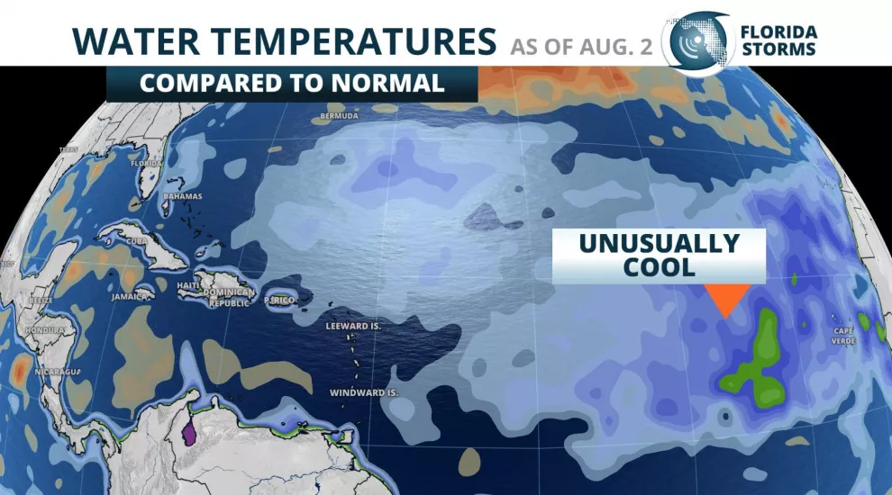
Phil says sea surface temperatures across the Main Development Region are “some of the coldest on record for this time of year”. The MDR is the area of the Atlantic where most tropical storms and hurricanes form, especially the strong ones. When conditions are unfavorable for tropical activity in this region, it usually correlates to fewer storms over the course of the entire season.
The cooler Atlantic waters are largely attributed to higher-than-normal pressure tendencies, which in turn produce stronger trade winds from the east that cause more ocean upwelling. These winds also aid in the spread of the Saharan Air Layer, which is often filled with dust from sandstorms over north Africa. The dust also reduces solar insolation, further contributing to the cooler than normal Atlantic waters.
It is worth noting, however, that water temperatures in portions of the Gulf of Mexico and in the western Caribbean are warmer than normal. Dr. Klotzbach says this is unrelated to what is the primary driver of his forecast.
“The Gulf of Mexico tends to be more of a wild card. What goes on in the deep tropics isn't necessary what's going to go on in the Gulf, considering it's a bit further north.”
Joe Bastardi is the lead forecaster for Weatherbell Analytics, a private forecast consulting firm based out of New York. He compares current conditions to years with similar conditions in the past (referred to as analogs) to formulate his forecast. One of those signals is an abnormal cool spell he expects to develop over eastern portions of North America in the next couple of months, which Joe says could affect conditions just offshore.
“You always have to worry for the atmosphere having a tendency for greater amounts of upward motion closer to the coast.”
This upward motion is what can trigger the development of a tropical storm.
“A storm when it starts to form, it doesn't care if it came from Africa or not. All it cares about is the local conditions that it's in,” Bastardi adds, referring to water temperatures close to the United States that are warm enough. “So that if you get something spinning in your backyard, it can spin up quickly.”
Joe can cite dozens of times this has happened since hurricanes were first charted in the late 1800's. The most common example is Hurricane Andrew in 1992, which was the first named storm to develop that year and one that didn't intensify until it was only a couple of days from making landfall in South Florida. Two of the most destructive hurricanes in our nation's history, Alicia (Texas, 1983) and the Labor Day Hurricane of 1935 (Florida), both became monsters within only a few hundred miles of moving ashore. Other more recent examples of nearby significant, and seemingly sudden, tropical developments include Major Hurricanes Isidore and Lili in the Gulf of Mexico (2002), Hurricane Arthur in North Carolina (2014), and Hurricane Chris that rapidly intensified just off the Mid-Atlantic Coast in July of this year.
Since this is likely to be an non-traditional season in terms of where tropical storms might form or track, both Phil and Joe remind residents in hurricane-prone areas to stay vigilant in preparations for the season ahead. Dr. Klotzbach says this every year.
“Regardless of the seasonal forecast, everyone needs to be prepared, because it only takes that one hurricane making landfall where you live to make it active for you."
More than two-thirds of the activity during the Atlantic hurricane season develops after August 15th, which officially ends November 30. As of August 2, the National Hurricane Center says no tropical cyclone development is expected in the next five days.
